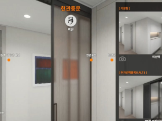
A high-quality real-time housing visualization solution that is optimized for unit households of a multi-household residence. By utilizing optimized architectural CG and a game engine, all plans and options can be visualized within 0.5 seconds. By applying 25 options for each project site, a total of 33,554,432 combinations of options can be realized in real life.
A housing visualization solution for the inside of each household in a multi-household residence utilizing the latest game engine technology. This technology can allow the consumers to check out the units they purchased before the completion of construction and purchase options, enhancing customer satisfaction.
Project references : e-Pyeonhansaesang Tangjeong, Yangju, Shiheung, Geomdan, and many more.
Intellectual property right : C-2023-014875
2. Smart Safety Control Solution Technology
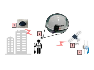
This is a solution that can prevent equipment accidents and safety accidents to workers utilizing cameras, AI, IoT sensors, and wireless communication technologies. Safety pagers and danger zone warning systems can be used to inform a worker when he/she approaches a danger zone, ensuring workers can perform their work safely. The PAMS allows the measurement of the driving and rebound of piles from a distance of 20m, preventing accidents to workers.
Danger zone warning device
A system that prevents workers from approaching a danger zone using radar sensors. Higher accuracy by enhanced attachment, 180-degree detection radius for sensors, and three-level distance adjustment (3m, 5m, and 7m).
Project references : Acro REITs County, e-Pyeonhansaesang Jaesong/Anyang, LG Chemical ABS, Busan New Port, and many more.
Intellectual property rights : 20-2023-0001269, 30-2023-0023722
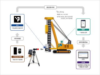
Pile Automatic Measurement System (PAMS)
Dedicated imaging equipment, platform, AIs are utilized in this automatic measurement system for pile driving and rebounding. 2Easy to use and accurate by imaging from a distance of 20m and attaching markers on hammers, caps, and piles.
Intellectual property rights : 10-2507543, C-2022-026158
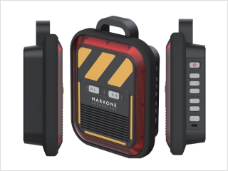
Safety Pager
A worker positioning solution utilizing a control platform, LoRa communication network + safety device (beacons and trackers). A smart safety management system that utilizes the real-time positional information of workers based on IoT. TBM management, early morning/night time shift management, Spot danger zones and high-risk worker management, SOS distress call, etc.
Project references : e-Pyeonhansaesang Gangdong/Songdo/echo-delta, and ACRO Samsung., etc.
A solution where the AI, drone, and IoT Sensor technologies are used to digitalize and automate quality control in each phase of construction.
By automating the conventional quality inspection methods, which were expensive and inefficient, you can enhance your productivity.
The system supports objective data gathering based on images and video analyses, and the platform can be used to generate a report automatically.
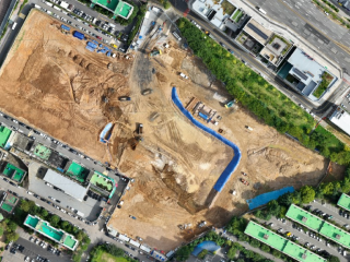
3D-based Earthwork Management Solution
A construction site drone management system that can take care of the entire processes of photo-taking -> align -> analysis -> application. orthomosaic images, 3d models, numeric elevation model, and 360 images, etc., can be generated to calculate the distance, area, and volume.
Project reference : e-Pyeonhansaesang Shiheung, Geumjeong, Moonjeong, and Tangjeong, etc.
Intellectual property right : C-2023-042370
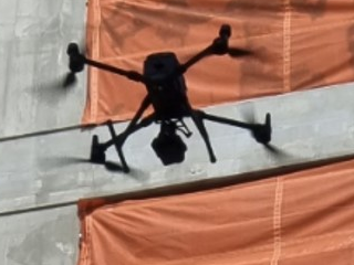
Crack N Drone
A system to inspect the exterior wall of a apartment where a drone shooting -> 3D joining -> align, and -> Automatic Report Generation. A total inspection of the exterior wall before the official completion of the construction and corresponding repair works to prevent water leakage defects on exterior walls.
Project references : e-Pyeonhansaesang Cheonan Station, Yeoncheon, Bupyeong, Geoje, Geomdan, and many more.
Intellectual property rights : 10-2456987, C-2022-040497
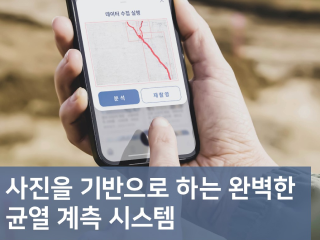
Crack N
A concrete crack measurement platform utilizing a camera, AI, and wireless communication Technology. The system is capable of analyzing cracks of 0.01mm or larger. As a result, it can be utilized in field Crack inspection for the maintenance after completion or for new project site of the company.
Project references : e-Pyeonhansaesang Shiheung, Wonju, Anyang, Gang-dong, Saemangeu-Jeonju High Speed Sector 7, and many more.
Intellectual property rights : 10-2635926, 10-2023-0189704, C-2023-038937
4. Smart Home Controller Technology
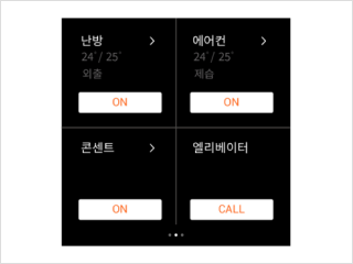
A smart switch that can control bedroom lighting, heating, air-conditioner, and even call the elevator using a full-touch display and voice recognition. The product reflects the experience of the users on display screen touches due to the popularity of digital devices in addition to the improvement of the appearance by integrating lighting and thermostats, etc. Our Bluetooth product can be connected without separate wiring or duct work. Everything can be controlled by a single smart switch.
Smart Display Switch
A full-touch display switch that integrates lighting switches and thermostats. The multi-function Switches can control the air-conditioner and lock the cooking stove, etc. not only with the touch but also your voice.
Project reference : e-Pyeonhansaesang Tangjeong and more.
Intellectual property rights : 10-2022-0097313, 30-2022-0025002